Stone Tools Found Underwater Reveal Australia’s Lost Landscape
Stone tools found underwater off Western Australia reveal ancient Aboriginal activity in a landscape submerged at least 9,000 years ago.

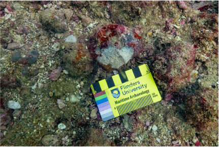
Stone tools found during underwater archaeology in Australia are revealing how Aboriginal communities used a landscape that now lies beneath the sea. Off the coast of Western Australia, archaeologists and Indigenous Rangers documented artifacts at two submerged sites near Murujuga, an area with a long history of Aboriginal cultural connection.
The sites were underwater at least 9,000 years ago, after rising sea levels flooded parts of the continent’s former coastline. The artifacts themselves could be older, although researchers have not yet established their exact age.
The findings, published in Quaternary Science Reviews, add evidence that the seabed preserves a much larger archaeological landscape than previously documented.
Two Underwater Sites Reveal a Lost Landscape
The research focused on two locations near Murujuga, in Western Australia’s Dampier Archipelago. Both sites lie beneath the water in places that were once dry land. One site is associated with an ancient freshwater spring. Before rising seas covered the area, the spring would have provided a source of fresh water for people living or traveling nearby.
The second site, known as Maitland River Hummock, lies near a rocky hill overlooking an ancient river channel. Researchers identified stone artifacts in an area where the exposed rock could have supplied material for making tools. Together, the locations offer evidence of how people used different parts of the landscape. Fresh water, access to stone and nearby waterways would have made these places useful for different activities. Researchers have not claimed that the sites reveal a complete picture of daily life. Instead, the finds provide new evidence that ancient activity extended across a landscape that is now submerged.
Stone Tools Reveal the Movement of Raw Materials
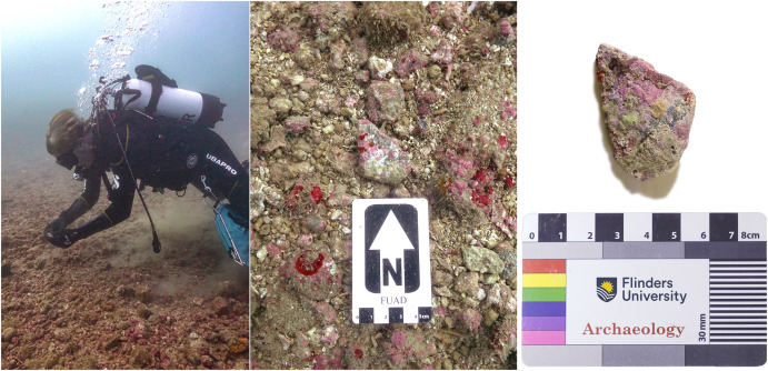
The recovered artifacts include stone cores, flakes and shaped tools. These objects can help researchers understand how people selected stone and worked it into useful forms. Analysis showed that some artifacts were made from stone sourced around Rosemary Island, approximately 23 kilometers from where the objects were found. This suggests that people moved stone across the landscape, which is now seabed.
Researchers have not established exactly how that movement happened. People may have carried the material themselves, or it may have passed between neighboring groups through exchange. The available evidence does not settle which explanation is correct. The findings nevertheless point to the use of stone resources beyond the immediate area where the artifacts were recovered. By comparing the materials at each site, researchers can investigate how people selected and transported resources across the archipelago.
Indigenous Rangers Helped Find the Artifacts
The research brought together archaeologists from Flinders University, the University of Western Australia, James Cook University and the University of York with the Murujuga Aboriginal Corporation. Rangers from the corporation trained as scientific divers and took part in underwater surveys. Malik Churnside and Richard Variakojis helped locate and document the sites, and both contributed to the published study. Churnside discovered one of the stone artifacts during a survey dive.
Their involvement is important to the project’s approach to archaeological research and cultural heritage. The work combines scientific investigation with the knowledge and participation of the Traditional Owners whose connection to Murujuga continues today. Vincent Adams, director of the Murujuga Aboriginal Corporation, said the findings show that the cultural landscape extends beyond the modern shoreline and into Sea Country. For the Ngarda-Ngarli people, Murujuga is not simply an archaeological location. It remains a living cultural landscape, parts of which are now preserved beneath the water.
Rising Seas Preserved Evidence of Ancient Life
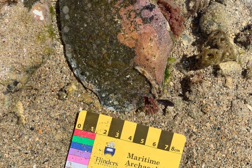
At the end of the last Ice Age, rising sea levels flooded large areas of land around Australia. More than two million square kilometers of the continent’s continental shelf eventually went underwater. Before that flooding, generations of First Nations people lived across these landscapes. Some evidence of their lives is now underwater, where archaeological sites remain difficult to locate and investigate. The new findings build on earlier underwater discoveries near Murujuga reported in 2020 and 2023. Rather than treating each location as an isolated find, researchers argue that the sites form part of a broader submerged cultural landscape.
The study also demonstrates why underwater archaeology in Australia matters beyond the recovery of individual tools. Mapping the surrounding seabed and examining the geological setting can help researchers understand where people traveled, found resources and used the landscape before sea levels rose. However, the submerged sites remain only partly explored. More surveys and analysis will be needed to determine how extensive the archaeological record is and what further evidence it may contain.
A Wider Archaeological Record Beneath the Sea
The discovery adds to the evidence that rising sea levels did more than change Australia’s coastline. They also submerged places where people had lived, found fresh water and gathered materials for tools. Researchers say the sites need to be identified and protected as part of the region’s cultural heritage. Much of the submerged landscape remains unexplored, leaving open questions about how ancient communities used the area.
For now, the artifacts provide tangible evidence of human activity in places that later became seabed. Further research may reveal more about the people who occupied this landscape and how they moved resources across it. The findings also make clear that Australia’s archaeological record does not end at the present shoreline. Some of its evidence remains underwater, waiting to be documented.